




Sky High Bull's-Eye Drone Ground Control Point GCP - UAV Aerial Target for Mapping & Surveying (10 Pack) | Center Eyelet Numbered 0-9 (Black/White Markers) | Pix4D & DroneDeploy Compatible — Open-Box, 23% Off
Brand: Sky High Bull's-Eye
Description
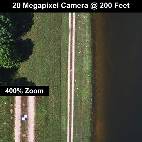
Enhanced Field Coordination: These UAV aerial drone center eyelets numbered survey markers enable effortless identification and precise coordinate tracking, streamlining your operations in the field. Easily locate and reference specific points during mapping missions.
Optimal Visibility: The black/white color scheme in these uav drone aerial targets is specifically designed to ensure excellent target visibility even in bright and challenging lighting conditions. Maintain clear visual reference points for accurate data collection.
Secure Ground Placement: Equipped with four corner eyelets, these drone target center points can be conveniently fixed to the ground. This feature guarantees stability during data capture, providing consistent and reliable results.
Lightweight Durability: Crafted from a lightweight yet durable material, this high point ground marker offers long-lasting performance in demanding environments. Its robust construction ensures resistance to wear and tear, making it a reliable companion for your mapping and surveying endeavors.
WORKS WITH LEADING PHOTOGRAMMETRY SOFTWARE - Pix4D, DroneDeploy, Metashape, OpenDroneMap/WebODM, UAV4GEO Lightning, DJI Terra, Esri Drone2Map, Bentley ContextCapture, SimActive Correlator3D, 3Dsurvey, Propeller, Global Mapper Pro & RealityCapture
Introducing the Center Eyelets Numbered 0-9 Sky High Bull's-Eye Ground Control Point, a revolutionary tool designed to elevate your mapping and surveying endeavors to new heights. With its innovative features and exceptional functionality, this center point fly marker is a must-have for professionals in the field. The numbered markers featured on the Sky High Bull's Eye GCP provide unparalleled convenience and efficiency. Easily identify and track specific coordinates during your mapping missions, enabling seamless collaboration between team members. No more time wasted searching for reference points—simply locate the numbered spot markers and capture accurate data with ease. Whether you're conducting large-scale surveys or intricate mapping projects, this drone target ground point ensures precise and reliable results every time. Designed with optimal visibility in mind, the black/white color scheme of the ground control target guarantees clear and distinct target exposure even in the brightest conditions. Say goodbye to squinting and straining your eyes to locate targets under harsh sunlight. The contrasting colors of the mapping drone survey targets allow for easy identification, ensuring accurate data collection and analysis. Maintain superior visual reference points with the Sky High Bull's Eye Center Eyelets GCP and experience a new level of efficiency in your mapping and surveying operations. Constructed from a lightweight yet durable material, the aerial survey targets is built to withstand the rigors of the field. Its sturdy design ensures longevity and resilience, providing you with a reliable companion throughout mapping missions. Whether you're navigating rugged terrains or facing weather conditions, these survey drone ground targets stand up to the challenge. Rest assured that your investment is protected, and focus on collecting precise data.
Sold by
Amazon Warehouse
Official Amazon outlet for open-box & returned items
- Backed by Amazon's A-to-Z Guarantee
- 30-day return policy
- Ships from Amazon fulfillment centers
- Price verified on Amazon
Product Details
- SKU:
- awhd-us-b07jksq72m
- Model:
- GCP_24x24_004
- Country:
- US
- ASIN:
- B07JKSQ72M
- UPC:
- 757284191176
Shopping Smarter
Common questions about buying open-box and refurbished.


